The N70: It turns out that they’ve been hiding the hills from us.
When the Council of Europe declared the year 1970 as a year for nature conservation, the city of Nijmegen took this idea and ran with it. They devised a walking path that would get people, even people less familiar with nature, to appreciate all there is just within the municipality itself.
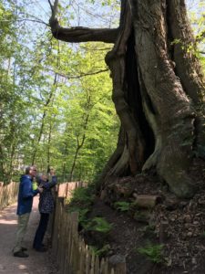
It is chock-full of beautiful views and well-situated benches from which to enjoy them, sunny meadows, magical shady forests, several possible stops for refreshment, and the Netherlands’ girthiest tree. It is largely on unpaved surfaces, which is a plus in our book. And its hilliness is something we’ve never seen in the Netherlands; altogether you take in eight hills, more than we’ve seen on one walk anywhere in the Netherlands. So why the name? N70 sounds more like a rural highway where drunk drivers hit a lot of wildlife. The N refers either to Nijmegen or Nature (or both) and 70 to 1970. Many Dutch walking enthusiasts call it “the most beautiful walk in the Netherlands” and we are inclined to believe them. It is simply stunning.
Perhaps its most striking feature besides being unbelievably topographical is that it is so well marked you cannot get lost. This is important and appealing. The Netherlands’ dense crisscrossing of roads with walking, bridle, and bike paths can be dizzying. Directions are usually available but intricate. Although we like to hike a lot, and we like maps, we still occasionally get lost, or think we might be lost. So we stop a lot. We sometimes realize that we’ve spent a hefty chunk of the last few hours looking at the map or our phones and not at the great outdoors. So when we heard the N70 described as so well marked you don’t need a map, our hearts leaped.
The many posts and other markers along the N70 are always green. As long as you don’t have red-green color blindness, you cannot get lost. At any intersection where you might start to even wonder, there’s the bright green post showing you the way. (There is one iffy corner at Kalorama Care Center, though; our advice is to stay level, whichever direction you’re going.) Sometimes they add a little metal label, very occasionally a homemade-looking sign. Sometimes two or three routes share the post. No worries, just follow the green. If you’re not sure, take a few steps down each of your options and one of them will have it. One pole had a few leaves camouflaging it but the route seems well enough maintained that it doesn’t get overgrown.
Have we already mentioned the fact that you cannot get lost?
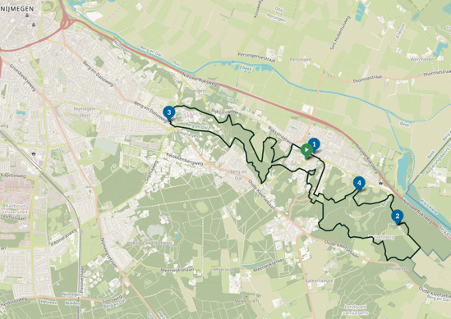
Officially the route is 14.2 kilometers long. Other sources like the Forest Service say 16. Our theory is that if you’re looking at the map thinking it describes a flat situation, it’s 14.2, while it’s in fact so hilly that if you count the distance you’ve actually walked you’ll come out to more like 16. Imagine the actual distance a horse going up and down on a merry-go-round travels compared with the size of its circular route. It really is that hilly.
We’ve already mentioned that the green poles make it impossible to get lost on this route. What you can do, though, is misinterpret them. We interpreted one to mean “go straight” when it actually meant “turn right”, but we had gotten so cocksure we hadn’t noticed that in the language of hiking posts the path took a right turn. But when you get to an intersection and see no green stripes anywhere, you know right away something’s wrong, so it was easily corrected and we lost very little time.
The route is a long loop with several possible starting points. Our starting and ending point was right in front of the restaurant Tante Koosje, on Berg en Dalseweg right near the edge of Nijmegen (easily accessible by public transit). The plan was to set out around noon, have sandwiches on the trail, and hit the restaurant for dinner. Knowing that 14 km usually takes us three or four hours (including breaks) we had given ourselves a little leeway and reserved for 6:30.
The river (roughly north) side of the long loop is slightly less dramatic, and includes a view across the river to the village of Persingen and its 15th-century church. For about 500 m you are on the pavement of Beek’s main drag (which includes a couple of places to eat, and a hotel.) The hillier half includes the Duivelsberg (“Devil’s Mountain”), site of a medieval castle and a story involving two feuding sisters, bloodshed, and perhaps poison. (It’s also right nearby another pleasant watering hole, the Duivelsberg Pannenkoekenrestaurant, where birdsong plays in the WC; sometimes it’s the little things.)
Liberated from having to hold a map and thus with four free hands between us, we gleefully used all of them by turns to point out one green pole after the next. Sign language replaced the need to ask out loud, and brought the birdsongs into sharper relief. Our anxiety gradually transformed into confidence. We sailed along, up and down, looking out over the river, ambling along past meadows full of wildflowers… For a while, we even thought we might get to dinner a couple of hours too early. There was so much up and down that the novelty wore off. We even started to wonder if it could please level out for a little while. Instead of three or four hours, this one had us busy for six, and if we’d had to stop to look at a map it might have been seven! But they were six hours that thoroughly thrilled us. It was like—after literally decades of searching—finally finding the hills we knew they’d hidden someplace.
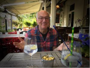
We ended up getting to the restaurant about a half hour early , and celebrated a beautiful hike with gin and tonics and a good meal. All’s well that ends well.
Tante Koosje is a cozy restaurant situated on one of the main arteries from Nijmegen to the town of Berg en Dal (“Mountain and Valley”, which given we went up and down eight hills seems odd in the singular). In nice weather you can sit outside. The wait staff, all young women in floral dresses, manage to make you feel welcome, and also seem to know their stuff. Food is colorful, tasty, and not overpriced. There are a couple of unfussy but creative veg options, and the wines we had were good matches.
Berg en Dalseweg 359 / 024-3222750 / tantekoosje.nl / open Tues-Fri 4-10 p.m., Sat/Sun 12-10 p.m.
Practical info:
Distance: 14.2 km (8.9 miles), kind of
Elevation change: 325m,
Map: none needed! Follow green-striped posts (there is a document with directions, 18 pages long)
Download route and shorter versions (in Dutch): https://www.staatsbosbeheer.nl/-/media/rijk-van-nijmegen/wandelroute-n70-rijk-van-nijmegen.pdf
Features: shade when trees are in leaf, hills, views, many refreshment stops, multiple access points
Note that this walk is easily accessible on public transit. From Nijmegen rail station, Breng bus 2 (towards Maartensklinkiek) or 8 (towards Berg en Dal) will get you to where we began. Another thing to note is that there are way more benches on the south side.
You can also start at one of the two Fletcher Hotels in Berg en Dal, along the main drag in the town of Beek (take Breng bus 80 towards Millingen), or the Duivelsberg. With a very cute ice cream store and a used bookshop in addition to a hotel and restaurants, you could easily start and end up here)
starting points (in NL) https://www.visitnijmegen.com/routes/3673389898/n70-natuurwandelroute
Description in Dutch but of course you don’t need it: https://www.visitnijmegen.com/routes/3673389898/n70-natuurwandelroute